SAVAGE CONCEPTS
Spaces & Places
Prototypes
From seeing the contrast in the old images from leicester vs the location I knew, I thought it would be interesting to see the old images of plymouth and how they relate to the places that we see now.


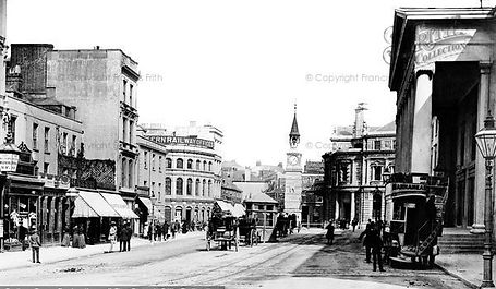


These images were found from the Frances Frith collection and show in great detail the style and times of the era's they represent, some such as George street are from 1892 where as Mutley plain is 1904. contrasting these images with Google map equivalent for the area has allowed me to see quickly what areas have seen the biggest changes.
Intervention part 1
Th efirst attempt at this intervention, I printed the images on to tracing paper, so that it would be possible to see the images of the photos but also see the modern day space behind. This was not successful as the images were too difficult to see the modern day through. However it gave me the time to see where the locations were, adn to see, for instance the image of the pier had a tree that was blocking the view, so another image was going to be needed anyway.
The image of George street that I had printed on Acetate, I placed inside an old photo frame as a meant to keep the image straight. this didn't work as the frame was then too heavy to hold for long periods of time and also carrying it around town i was weary about the glass being broken.


Intervention part 2
For the second attempt, I tried a bigger image and used a mount card to hold the images so they were light weight. I also had a bamboo cane to attach to one of the images to enable the image to be lined up. this worked well as the Smeeton's tower image, was shot from nearly ground level and it allowed me to line up the image first.


