SAVAGE CONCEPTS
Spaces & Places
Research

Starting by exploring the brief, I looked up some of the key terms used. Identity has varying definitions from Oxford dictionary and Cambridge dictionary, and how there is a value placed in identity when looking at it in the sense of being lost or a business reputation. Additionally, using mapping as a way to explore Plymouth, I set about to see what identified Plymouth as Plymouth, and what losing that identity would do.

Exploring Maps as a way to present information in an abstracted view, the book ‘The Map as Art by Katherine Harman had an excellent collection of maps that are displaying information in a distorted manner, such as the infographic to the left. This style of infographic appeals to me as a way to display information where it is a true reflection of the data but maybe not as useful to be read. It displays the information in relative terms but not in actual terms.


Using the A-to-Z map of Plymouth as a starting point, I wanted to boil the city down into a map purely of experiences. With 3 categories, I created overlays to place on the map. The categories were as followed:
How you move/connect
-
Roundabouts
-
One way arrows
-
Post offices
-
Parking
-
Ferry terminal
Self improvement
-
Schools
-
University buildings
-
Doctors surgery's
Enrichment
-
Theatres
-
Sailing clubs
-
Cinemas
-
Shopping centers
-
Churches
-
Museums
By looking at the experiences isolated to the land mass, the ability to recognise Plymouth becomes distorted, however the experiences become somewhat more unified when they have the presence of the land mass over the top.
The question then is - is it the geography that allows us to recognise a place, or is it the experiences that we have whilst in a space? What it is that creates the attachment?
Is the identity within the experience or in the place.
If then the landmass/coastline is reversed, but not distorted – do we still see it in the same way – is that connection still there?
At what point is an identity lost? How easy is it to be lost?


Being new to Plymouth, I wanted to have the opportunity to explore Plymouth for myself just through experiences. At this current point my experiences were limited, mostly in the walk to and from the uni to my house. To experience the walk just in the experiences along the way, I transcribed my walk to the uni – no street names or starti8ng points. Just through the experiences along the way, I wondered if it would be possible for someone to get an understanding of where I had been or where I was walking. By ‘stopping and smelling the roses’ as it were, I was able to build up a rich series of descriptions of the areas around me and what I was seeing hearing and smelling. It goes beyond the getting from A to B

From the known route, to the unknown – I chose the gate at Royal William ard a s a starting point, and with a modified dice, carved out a route through a series of left, right and straight-ahead instructions. This was recorded through photos. The ambition was that the experiences that I would have around this area of the city, would be random leading to unusual and unforeseen outcomes.by removing the choice from this, I would have gone places that weren’t predefined or part of my character. The downside of this experience was that given the close nature of the area, I found myself in a dense residential area, and unable to follow out the instructions on the dice, as I would be stuck in a car park or ion people’s properties. All routes were leading the same way.
Reflection on the exploration so far
After reviewing the outcomes from my exploration so far, I thought that although I had found the value in the identity and had explored my own personal experiences of Plymouth, I wasn’t sure how they would translate into an intervention for others.
The choice of Royal WIlliam Yard as a starting point hindered the option of a random series of events. At this point, I had an option to start the experiment again at a different point or to go back to he mind map at the beginning and choose another starting point to look at.
Referring back to the mind map, I started looking for historical maps of Plymouth. My experience of Plymouth is based on the Plymouth that is here at this point, and that it would vary from the people from the past. With a culture that is so heavily based in military history and Naval exploits I started to look at the past historical maps of Plymouth in the hope to see how the land mass has changed over the years. From a range of maps from old maps online, I came across a map from the 1940’s from the Nazi’s. This was a shock as I would have assumed that this wouldn’t have been so readily available.


To get a better understanding of where I wanted to take this project, I decided to turn my focus to the other place. Within this project, I wasn't sure what this other place should be, should it be a place that was coastal or military or have another connection to Plymouth - i.e. New Plymouth in New Zealand.
However, I decided that I was going to pick Leicester for a couple of reasons.
1. I know it well, having moved to Leicester for my BA course, and having returned 2 years after graduating.
2. Being new to Plymouth, it is a place that I called home.
3. With me and my experiences being the link between these two places, I could focus on the personal side to the project that I had started to explore with the thoughts around identity and its importance.
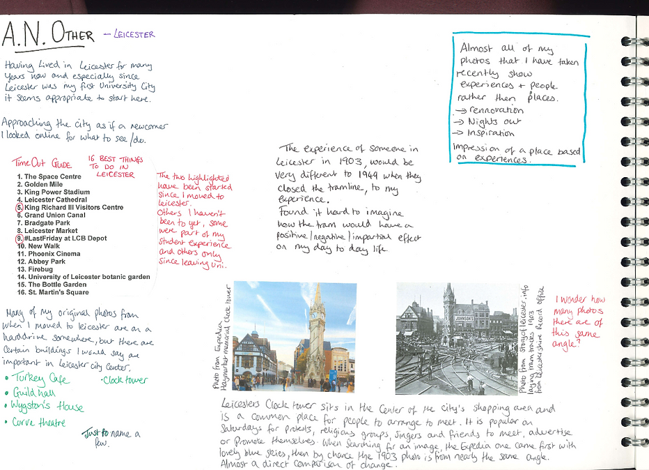
From the Time out guide of the best things to do in Leicester as a starting point, I then reflected on the photos that I have from Leicester and where they were taken. The clock tower is a key meeting point within the city, with the pedestrian streets spreading away from this point down the shopping streets. With the old maps fresh in my mind, I wondered what the clock tower would have looked like many years ago, and discovered that there were tram lines that run around the city, with an image showing the tracks being laid. I wasn’t away that there had been a tram line there, and had always assumed that it was for roads. The modern day photo of the clock tower and the photo from the tracks being laid happened to be in roughly the same direction and led me to wonder – for such a well known place in Leicester, how many photos have been taken from that same point? How many people through the years have taken a photo from that spot and could document the changes?